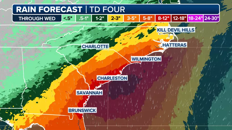

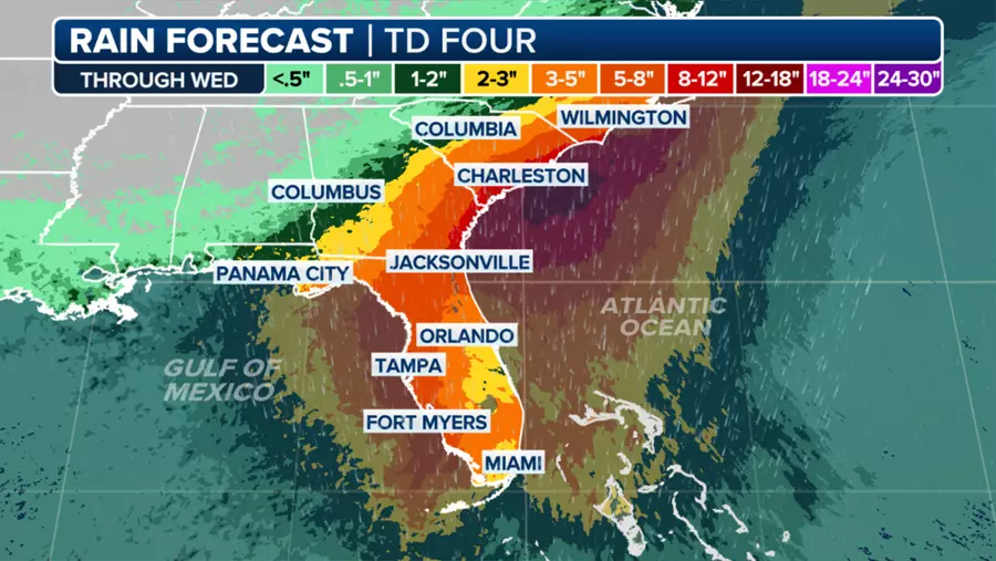
A Hurricane Watch has been issued for a portion of Florida’s Gulf coast as Tropical Depression Four threatens to bring heavy rains, strong winds and a possible life-threatening storm surge. The National Hurricane Center Director Michael Brennan stated that this event will be multi-hazard in nature, with the main dangers being widespread heavy rainfall of 5-10 inches across much of Florida and into the southeastern United States, with some isolated areas receiving up to 15 inches. This poses a significant risk for freshwater flooding and also the potential for storm surge.
Tropical downpours and gusty winds have already begun spreading northwards across the Sunshine State, and are expected to continue through Saturday. The FOX Forecast Center anticipates this disturbance will strengthen into a tropical storm over the eastern Gulf of Mexico and move northeastward towards Florida’s Gulf Coast within the next 36 hours. Upon organizing and reaching sustained winds of 40 mph, it will be named Debby.
The storm is currently tracking farther west than earlier forecasts, which delays the time of landfall until Monday morning along Florida’s Big Bend region. If the storm moves closer to the coastline, it may make landfall sooner; however, if it remains over the warm waters of the Gulf, it could undergo further intensification and possibly reach hurricane strength before making landfall.
Regardless of its name or strength, the storm will bring heavy rain across Florida and trigger flash flooding in areas prone to flooding. Gusty winds are also a concern, particularly along the Gulf Coast, with gusts of 50-70 mph expected as the storm comes ashore. After making landfall, the storm’s forward speed will slow down considerably, bringing an extended period of rain, wind and potential coastal flooding that could persist into next week.
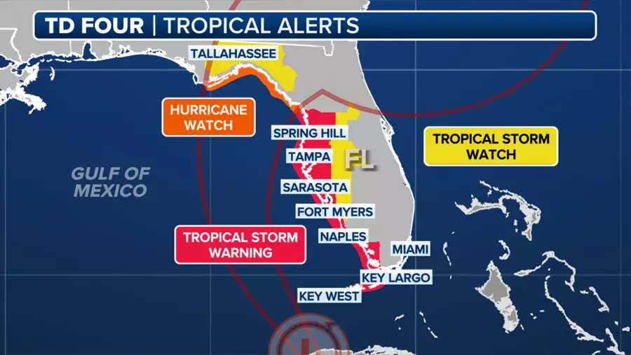
A Hurricane Watch is in effect for the Florida coast west of the Aucilla River to Indian Pass, indicating a possibility of hurricane-force winds of more than 74 mph within the next 48 hours. A Tropical Storm Warning is currently in place for the Florida Keys west of the Seven Mile Bridge, including the Dry Tortugas, as well as the western coast of the Florida peninsula from south of Yankeetown to East Cape Sable. Additionally, a Tropical Storm Watch has been issued for the Florida Keys south of the Channel 5 Bridge.
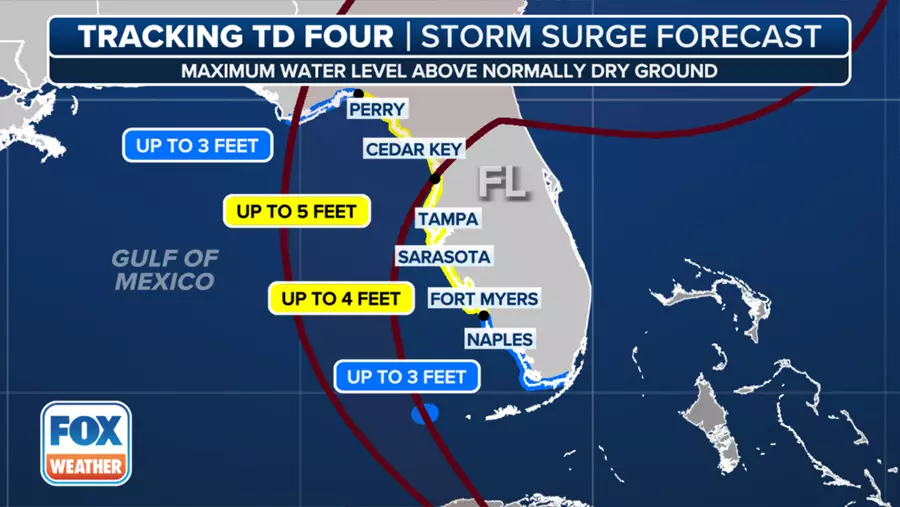
Storm surge warnings are in effect for Aripeka northward to the Aucilla River and a Storm Surge Watch is in place for Bonita Beach northward to Aripeka, including Tampa Bay and Charlotte Harbor, as well as west of the Aucilla River to Indian Pass. Although the NHC’s latest forecast cone issued on Saturday morning does not explicitly show the storm reaching hurricane strength, there is a possibility that the storm may undergo further intensification just before landfall on Monday.

Tropical storm-force winds are expected in the warned areas across southwestern Florida late Saturday into Saturday night, moving up the western coast of Florida into Sunday. Storm surge of 2-5 feet is possible along portions of Florida’s west coast, with the highest surge expected in the Big Bend area and up to 4 feet in Tampa Bay and Charlotte Harbor. A Flood Watch has been issued for all of South Florida, including Miami, effective through Sunday evening.
There remains great uncertainty about the storm’s fate once it makes landfall on Monday. Weakening steering currents will cause the storm to slow down over northern Florida, with forecast model guidance becoming split regarding its future path and intensity. This slow movement between Monday and Thursday raises concerns for heavy rainfall in coastal areas such as Savannah, Hilton Head, Charleston and southern North Carolina, potentially leading to flash flooding risk from Jacksonville, Florida, up to Myrtle Beach, South Carolina.
In conclusion, Tropical Depression Four poses a significant threat to Florida and the southeastern United States, bringing heavy rains, strong winds, and potential storm surge. Residents should prepare for adverse weather conditions during the second half of the weekend and into next week as the storm moves across the region.